|
||||
|
|
||||
|
|
|
Scrambling Pinnacle Mountain, Arkansas
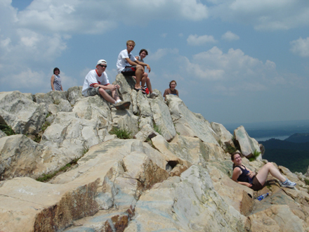
06.24.06 -- On Wednesday, June 21, 2006, MAGS members Mike, Sherri, Jennifer and Kelly Baldwin, Casey Randolph and friends Drew and Sarah travelled to Pinnacle Mountain, Arkansas for a day of rock scrambling and hiking. Pinnacle is only about 2 and a half hours west of Memphis, and 12 miles west of Little Rock, at the eastern end of the Ouachita Mountains (the only mountain range in the United States that runs east-west, rather than north-south). Pinnacle Mountain, a well-known cone-shaped peak is a central Arkansas landmark, rising 1,011 feet above sea level. Our trek was a challenging hike to the rocky apex of Pinnacle, which sits high above the Arkansas River, Big Maumelle River and the Little Maumelle River. The loop trail system consists of the East and West Summit Trails and Base Trail. Our group chose to take the East Summit Trail (the most challenging trail) to the top. We go to Pinnacle at least once a year. The first time we did this climb, we took the West Summit Trail, which consists of mostly sandstone slabs, laid out naturally almost like stairsteps. The East Trail is all boulders. You can't get to the top without scrambling -- using both hands and feet to pull yourself over the boulders, sometimes at angles of 75 degrees or more. The temperature Wednesday was about 95 degrees and the sun was beaming down. That made the reward at the top seem that much sweeter -- a 360 degree view of Little Rock and the surrounding area, and a nice, cool breeze. We chilled out at the summit for an hour or so before heading back down. Pinnacle Mountain was designated a state park in 1977. In addition to its appeal to hikers and picnickers, Pinnalce is a very interesting study in geology. During the Pennsylvanian period, 320 million years ago, Arkansas was almost entirely covered by ocean. This ocean environment deposited and the park’s principal layer of rock, Jackfork sandstone. A few fossilized remains of marine invertebrates, including brachiopods, crinoids, gastropods, bivalves, and cephalopods, have been discovered in the sandstone of Pinnacle. Pinnacle got its unique appearance through a process called thrust faulting. During the Pennsylvanian period, folding occurred and faults developed in the sedimentary rock of Pinnacle. This type of faulting (thrust faulting), often results in the older formations of rock being thrust over the younger rock. Pinnacle Mountain geology also includes veins of quartz, which formed when hydrothermal solutions rich in silica and other minerals passed through the layers of rock, leaving mineral deposits in the cracks and cavities. An igneous rock formation, formed during the Cretaceous Period, indicates the solidification of molten material. Finally, deposits of sands, silts, clays and gravel formed during the Pleistocene epoch of the Quaternary period are found at the base of the mountain. Along the Arkansas, Big Maumelle and Little Maumelle Rivers are deposits of alluvium which were deposited in the flood plains of the respective rivers. This article was written and photograph taken by MAGS member, Mike Baldwin ©2006
References:
|
||
|
|
||||